Contributed by Steve Weatherly
The Siuslaw National Forest (US Forest Service) unveiled an Interpretive Sign atop Mt Hebo this past Friday 8 Aug 14. When Mt Hebo AFS closed the site was returned to nature and for almost 30 years all visitors have seen of the site has been an empty meadow. The Sign lets visitors know that we were there and what we did!
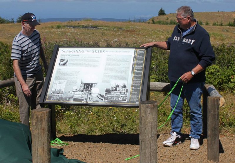
The photo below shows the actual unveiling done by two Mt Hebo AFS vets. One was there in the 50s (on right) and one in the 70s (on left). These were the decades that Mt Hebo AFS and the 689th were active.
Download the PDF file to see the pictures and text on the sign.
Part of the Cold War Landscape
Construction on the Mt. Hebo AFS began in 1953. The station was completed and operating by 1957.
Mt Hebo AFS was one of five "frontier" radar sites in the 25th NORAD) Region, responsible for air defense in the Pacific Northwest. By 1959, NORAD began to replace the AC&W system with the Semi-Automatic Ground Environment (SAGE) computer directed system for air defense.
Technologies and equipment changed over the 24 year life span of the Mt Hebo AFS, but the overarching mission to protect the Pacific Northwest from surprise air attack did not waver. The surveillance portion of Mt. Hebo AFS’s mission was transferred to the Federal Aviation Administration's (FAA) radar post in Salem, Oregon in 1979.
Radars
The first radar equipment operated at the station was the FPS-4 and FPS-6 height-finder radars and an MPS-11 search radar. By 1962 the 689th Radar Squadron (SAGE) began operating an FPS-24 search radar and FPS-26A and FPS-90 height-finder radars. The FPS-26A was modified into the FSS-7 Sea launched ballistic Missile (SLBM) sensor and tracking radar in 1966.
The FPS-24 search radar was housed in a five story (85’ tall) building. The radar antenna weighed 85.5 tons and was enclosed by a rigid radome about 145’ in diameter and 100’ tall to protect it from snow, ice, and high winds. Three separate radomes were installed in the period from 1962 to 1965. All three were destroyed by extreme weather. As a result the FPS-24 was removed and replaced by the smaller FPS-27 search radar in 1968.
Life & Community
Mt. Hebo AFS, like a small town, including a headquarters building, barracks for personnel, a dining hall, recreation center (with gym, movie theater, library, photo lab), a 2-lane bowling alley, barber shop, MARS Station, dental clinic, medical dispensary, NCO Club, motor pool, and commissary.
Supporting facilities included a 27 house family residence area about 2.5 miles below the main station, a ground/air radio station located about 2 miles to the east, and a rifle and pistol range about one mile to the east.
One of the more challenging aspects of life at the station was the weather. Winters can be extreme on Mt. Hebo, with heavy snow and very high winds. Corrugated metal sewer pipes were used for protected walkways. They were installed from building to building and even under the road on the main site to protect personnel from the high winds and massive amounts of snow and ice. “During high winds in the fall, stones as big as your fist would be blown around…” notes Steve Weatherly.
Personnel stationed at Mt. Hebo were also part of the local community. Children attended schools in Hebo, Cloverdale and Tillamook; families shopped in area stores; and servicemen played in community sport leagues. For the duration of its existence the presence of the Mt. Hebo AFS and the people that served there made a significant impact on the local community.
1953 Construction on the Mt. Hebo AFS begins under the supervision of the U.S. Army Corps of Engineers
1957 Station completed and operating under the command of the 689th Aircraft Control & Warning (AC&W) Squadron
1964 Mt Hebo AFS is integrated into the SAGE system and the 689th is re-designated as a Radar Squadron vice AC&W Squadron
1967 Detachment 2 of the 14th Missile Warning Squadron is activated to detect and track “Sea Launched Ballistic Missiles” using the FSS-7 SLBM radar
1979 The 689th Radar Squadron is deactivated on May 1st
1980 Detachment 2 of the 14th Missile Warning Squadron deactivated in September
1986 Mt. Hebo AFS demolished, completely removed.
Property is reverted back to the Siuslaw National Forest and subsequently returned to its natural state. Focus turns to restoration and special habitat management.
1990 Designation of Mt. Hebo as a Special Interest Area
2000 Extensive habitat restoration for the Silverspot Butterfly.
Photo descriptions and contributions (counter clockwise from top far left): Tunnel Design (1965), courtesy Steve Weatherly. Inside Radome (1966), courtesy Steve Weatherly. Salmon fishing (1967), courtesy Steve Weatherly. Compound (1960s), courtesy Dave Casteel.
Background – Radomes atop Mt Hebo (1960s).
You can see the location of the Sign on www.ocrg.org/camerapages/cameras.html See Site 1: Mt Hebo. The video is on the Gate/Entrance Cam Video . Today (10 Aug 14) I watched visitors stop and view the Sign. The sign location is just below the horizon towards the top of the frame and about a quarter of the way from the left to the right of the frame. Much easier to locate when a vehicle is parked and people are by the sign. You can see them reach out to the Sign. Sorry we ran out of time at the interviews (to many stories).